Sunday, March 30, 2014

Borden's Dairy

Location:  Chenango County
Year:   1857

Gail Borden Jr., the inventor of the milk condenser, established the Borden Dairy in Chenango County in 1857. Borden's became successful during the Civil War as the primary purveyor of condensed milk to the Union Army. 

In 1875, after the Civil War, Borden's began selling pasteurized and homogenized milk commercially, and pioneered the use of glass bottles (as opposed to tins or cans) in 1885. The company invented evaporated milk in 1892. During World War II, it invented non-dairy creamer, instant coffee, and other food products which became part of the standard c-rations of the miltary.

Borden's was for a long time the largest diary in the United States, manufacturing cheese, cheese products, ice cream, and snack cakes. Poor business planning led to the contraction of this vastly diversified company in the 1990s. 

At its peak, and taking advantage of its vast cattle herds, the company went into the adhesives and chemicals business and invented the popular product Elmer's Glue-All, which was, in fact, made out of Elmer.    

Elsie The Cow (presumably Elmer's wife) was introduced as the company's spokescow in 1937. 


Saturday, March 29, 2014

Inwood Hill Park

Location:   Northwestern Manhattan Island 
Year:   1926


Inwood Hill Park occupies the extreme northwestern tip of Manhattan Island, fronting on the Hudson River and the Harlem River. The park occupies a portion of the neighborhood of Inwood, an area which lies north of far more famous Harlem. Due to the quirks of geography, Inwood has always had a distinctly different "feel" than most other Manhattan neighborhoods, being more akin to the residential areas of Brooklyn and Queens than the bustling streets of lower Manhattan.


Hilly, heavily wooded, and only partially developed for urban dwellers, Inwood Hill Park is unique, not only among New York City parks, but among all the parks in the world. 


The park itself was established in 1926. Prior to that, the land was part of several large private estates.

The landforms within Inwood Hill Park were heavily glaciated, and evidence of the last Ice Age surrounds the park's visitors. Within its 200 acres lies the last remnant of the primeval forest that once covered all of Manhattan Island. Eastern Hemlocks once throve there (killed by a blight, they are being reintroduced), and the Bald Eagle has likewise been reintroduced to the park, once part of its native range.


Visitors to Inwood Hill Park get to experience what New York City was like before there was a New York City. The only remaining salt marsh on Manhattan Island lies within the park, as do a series of caves once occupied by prehistoric man, and later the Lenape Indians. 


Archaeological digs in Inwood Hill Park are a rich source of finds, allowing social scientists to understand the lifestyle of the earliest Manhattanites.  

The park is also the site of the purchase of Manhattan Island by the Dutch (for 24 guilders) from the Lenape in 1626, though the nearly 300 year old tulip tree that marked the spot died in 1938. Other trees in the park are far older, and some are over four feet in diameter. 


Friday, March 28, 2014

The Warships of Lake Ontario

Location:   Lake Ontario
Year:   1812

Many naval battles were fought between the United States and Great Britain on the Great Lakes. The British Navy held mastery over Lake Ontario during the latter half of the War of 1812, and it is the only one of the Great Lakes to have sunken warships of the time lying in her depths.


Thursday, March 27, 2014

No sh*t!

Location:   New York City
Year:   1857

Joseph C. Gayetty of New York City invented toilet paper on the roll in 1857. He is the progenitor of the great philosophical question: "Over? Or under?" However, he was not Mr. Whipple's maternal great-grandfather.


Suburban cowboys

Location:   Montauk, New York
Year:   1747

The first cattle ranch in what was to become the United States was founded at Montauk, on Long Island, in 1747.


Tuesday, March 25, 2014

Welcome To Peekamoose

Location:   Throughout New York State
Year:   Throughout New York History


Like all States, New York has a collection of odd place names. These are towns that make you stop and say, "Whoa" when you read their Welcome To signs.

Some of them are Native American names like Yaphank.  A few are old Dutch names like Yonkers. A few are combination names like Yaphank Yonkers and Otter Kill ("kill" is a Dutch word for a creek, stream or small river, and "kill" appears quite frequently on the New York State map). 

A few are names of States like Florida and Alabama, or foreign cities like Bath, Bagdad, Athol and Limerick. Several countries are represented, like Mexico, Cuba, Denmark, Russia, China and Belgium.  

Biblical names are very common. You can find Egypt in New York, as well as Bethany, Goshen, Land o' Goshen, Canaan, Jericho, Jerusalem, Moriah, Hebron, and Ephrath. 

Several reflect local history, like Dix Hills (once the land grant of a man named Richard), The Bronx (owned by Jonas Bronck and family), Burnt Hills (where there was a memorable fire), Horseheads (a town dedicated to the military horse), and Sheepshead Bay (a "Sheepshead" is a species of fish). 

A handful are surveyor's mistakes. When Westchester County was being surveyed, much of the land along the the Connecticut border was owned by a man named Harrison, and his property was called "Harrison's Purchase." When drawing in the village lines, someone divided "Harrison" and "Purchase," which are now two adjoining places. 

But then there are others, whimsical, bizarre, or having some personal, now mostly unremembered meanings for the founders of the towns.  Places like:


Basket
Breakabeen
Bullet Hole
Bulls Head
Busti
Butts Corner
Cat Elbow Corner
Cattown
Chili Center 

Climax
Conquest
Crafts
Dibbletown
Dogtail Corners
Dogtown
Doodletown
Fickles Corner
Fink Basin
Fireplace

Lava
Lonelyville
Mile of Woods
Mud Mills
North Pole Noseville
Oot Park
Owls Head
Owls Nest
Pail Shop Corners
Painted Post
Paradox
Peas Eddy
Peekamoose
Place Corners
Podunk
Protection
Pudding Hollow
Pumpkin Hook
Result
Rough and Ready
Scuttlehole
Shin Hollow
Shinhopple
Silvernails
Skunks Corner
Skytop
Sleepy Hollow
Surprise

Blame it on Biggins

Location:   Brooklyn
Year:   1946 
Brooklyn's Flatbush National Bank was the first to release bank-issued credit cards back in 1946, when John Biggins invented the "Charge-It" program between the bank and participating local merchants.

Sunday, March 23, 2014

Pizza Bagels

Location:   Massapequa, New York
Year:   Mid-1970s

Bagels are Jewish. Pizza is Italian. What better place to invent the pizza bagel than Massapequa, New York, known to locals as "Matzoh-Pizza" for it's large, mixed Italian and Jewish population?  

These are pizza bagels

Although many places have claimed to be the birthplace of the pizza bagel, only Massapequa holds the pedigree. The pizza bagel was invented sometime in the 1970s when someone had the brilliant idea of garnishing a lightly toasted bagel with tomato sauce and cheese and letting the concoction heat in their toaster oven at home. Soon enough, the idea spread, and pizza bagels began popping up for sale all over Long Island, then the New York Metro area, and then nationally. 

A classic pizza bagel is prepared by taking a plain bagel, slicing it in half, and lightly toasting it. The bagel halves are then garnished with sauce and cheese and baked for a few minutes until the cheese begins to melt.

Since the invention of the pizza bagel many variations have arisen. Typical pizza toppings are sometimes added. Different varieties of bagels are used. Sometimes the top half of the bagel is pressed down onto the bottom half creating a sandwich of sorts. All these varieties have a melange of different tastes. 

Prepackaged, frozen, and other processed pizza bagels are an abomination unto the Lord, and should only be resorted to if one finds oneself trapped in Mishawaka, Indiana for more than six months. In the winter. Alone. Without heat. Living in your car. And then only if death is the remaining additional option.

I don't know what this is, and I don't want to know. There is nothing "Natural" about this at "all".

 But the best pizza bagels follow the KISS rule:  "Keep it simple, stupid." 


The Good Rats

Location:   Long Island
Year:   1964

The Good Rats have been rightfully described as "the world's most famous unknown band." Their collegial fans include such famous performers as Kiss, Jon Bon Jovi, Billy Joel, Alec Baldwin, Rosie O'Donnell and others.  A number of performers, including The Ramones, have credited The Good Rats among their inspirations.

The Good Rats have opened worldwide for such acts as Bruce Springsteen, Aerosmith, The Ramones, Ozzy Osbourne, The Grateful Dead, Kiss, and Journey, among many more. 

The band is extremely proud to have been inducted into the Long Island Music Hall Of Fame along with Billy Joel, Kiss, The Ramones, Blue Oyster Cult, Pat Benatar, Barbra Streisand, Mariah Carey, and other world-famous locals.  


The Good Rats began as a college band at St. John's University in Queens, including Peppi Marchello, who was to become their scuff-voiced frontman. Their first album, The Good Rats, was released in 1969. 

The Vietnam War and other less earth-shattering events like girlfriends, marriages and relocations, led to many changes in the lineup, but Marchello remained the center of gravity. 


In 1974, the band released Tasty, an album of pop standards, ballads, and fusion, which gained them national attention as it charted across the country due to heavy airplay on the Album-Oriented Rock (AOR) stations of the day. The Good Rats went from an opening act to a headliner, and their stage antics (throwing rubber rats into the audience, using metal garbage cans as bongos) immensely entertained their audiences, A number of albums followed, among them Ratcity Blues and From Rats To Riches, none of which garnered the national attention of Tasty, though the band remained a local favorite.

In 1980, the band broke up, but Peppi Marchello and his brothers and sons continued playing local New York venues, and other old (and new) bandmates slowly began coalescing around the Marchello core. In the mid-1990s The Good Rats qua The Good Rats began playing again as The Good Rats. They continue to release albums and to play smaller venues. 

On July 10, 2013, Peppi Marchello died at age 68, following cardiac surgery. 

The band plays on. 

This post is dedicated to Donna Heder who inspired it, and to the memory of Peppi Marchello, without whom it could not have been written. 


Saturday, March 22, 2014

Checkmate

Location:   New York City
Year:   1843

The first chess tournament in the United States took place in Manhattan in 1843.


Thursday, March 20, 2014

The Allegheny Plateau

Location:   The Southern Tier
Year:   420 million years ago

The Allegheny Plateau is a broad landform that makes up almost all of the Southern Tier of New York State. Geologically, it is part of the Appalachian Mountains. The Plateau is a worn-down portion of that mountain range, with remnant rolling hills and many lakes and rivers. It lies mostly to the west of the high peaks of the Appalachians, and stretches in a southwesterly direction through Pennsylvania, Ohio, West Virginia, and Kentucky, paralleling the high ridges. 

The Plateau's northern end is in central New York State. In New York State it stretches as far north as Syracuse, as far east as Albany and Monticello, and as far west as Jamestown. 

During the last Ice Age, the retreating glaciers carved out New York's famous Finger Lakes and left a series of low-lying hills (terminal moraines) across the region. 

Most of the Plateau was historically heavily forested with good soils. The Iroquois used the Plateau for both agriculture and hunting. When Europeans entered the region they cleared much of this aboriginal forest and turned it into farmland. It is New York's breadbasket, and the heartland of New York State's important dairy industry.   


Wednesday, March 19, 2014

The Official State Shell

Location:   Coastal Waters
Year:   1988

In 1988, New York declared the lowly blue-eyed (22 of them!) Bay Scallop (Argopecten irradians) as the official State Shell. Bay Scallops are found---hey, guess what!---in New York's bays. They grow to be as much as 3 1/2 inches wide and have 13 to 22 ridges on them. They are hermaphroditic, which should put a certain segment of the population into a tizzy. 

They are tasty, and in places have been overharvested.  

No news on whether the bivalve inside gets a liner credit.


Tuesday, March 18, 2014

Got Milk?

Location:   Upstate New York
Year:   1981

Good old milk is the official State Beverage of New York, which ranks third in the production of dairy products nationwide. Dairying is the backbone of the upstate economy.


Sunday, March 16, 2014

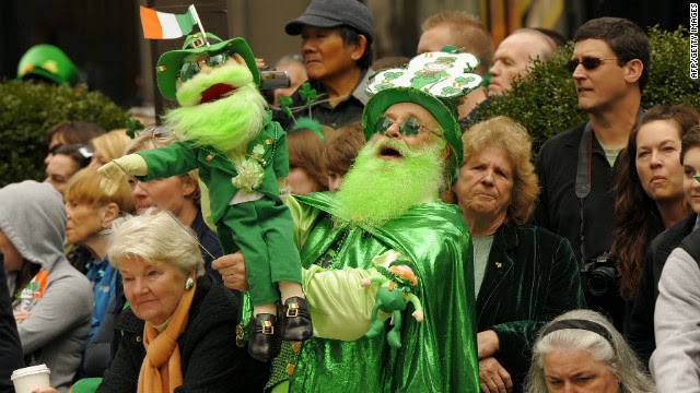
THE St. Patrick's Day Parade

Location:   New York City
Year:   1762


The first St. Patrick's Day celebration in New York City was a 1762 street fair hosted by a Mr. John Marshall, an Irish Protestant, outside his home, Mount Pleasant. Over the next several years, well-to-do persons of Irish descent hosted the annual street fair, held to remember the Old Sod. 


In 1766, the 16th and 47th Regiments of Foot, two British military units comprised entirely of Irishmen, met with the organizers of the street fair and arranged a parade of marchers to the old St. Patrick's Cathedral on the corner of Prince and Mott Streets in lower Manhattan. During the march someone was able to snare a fox.


The Parade became an annual popular event. Early St. Patrick Day Parades in New York were non-sectarian in nature as Irish-born Protestants outnumbered Irish Catholics in the city by a large margin. Historically, there was no animosity between the groups. Leaders of the movement for Irish independence were Protestant as often as not, men like Robert Emmet and Wolfe Tone.  

During the Revolutionary War, General George Washington ordered that his men (many of whom were of Irish and Scots-Irish descent) observe the holiday "in solidarity with the Irish and their own fight for independence." 

 
In 1776, New York City was occupied by the British who did not tolerate public celebrations of any separatist strain. While private celebrations undoubtedly continued, the annual public St. Patrick's Day Parade ceased to be held, beginning again only in 1784.   

Every year, parish churches would compete, attempting to field the most colorful and dramatic marching cadres, complete with bands and banners. This competition grew more intense in the 1840s, when millions of Irish immigrants fleeing the Potato Famine flooded New York. Around 1850, the Irish Fraternal Orders took over the organization of the Parade from the parish churches. 

 
In 1851, the all-Irish 69th Infantry Brigade (N.Y.) began guarding the parade route to forestall violence from club-wielding gangs, fisty drunks and rock-hurling nativists. During the Civil War, the "Fighting 69th" became the lead unit marching in the Parade, and it remains so to this day. 


The competition within the Parade was so fierce (and occasionally violent)  that in 1858, there were actually two competing St. Patrick's Day Parades in New York City. In 1860, the Ancient Order of Hibernians (AOH) took over the organization of the Parade, and calmed the chaos. In 1891, the AOH began using the now-traditional parade route down Fifth Avenue past the new St. Patrick's Cathedral.

New York's St. Patrick's Day Parade is a massive and popular event, drawing tens of thousands of marchers representing hundreds of groups from all over the United States, and millions of spectators. Thanks to the Irish diaspora, it is the largest parade of the most-widely celebrated holiday in the world.  

 
Although it has been afflicted by political issues over time, whether they be Nativism, Civil War, the Irish Troubles, the Choice question, or Gay Rights, regardless of the Issue of The Moment, there's no question that this brilliant  and beloved New York tradition will go on.


Tug Hill

Location:   The North Country
Year:  410 million B.C.E.

Tug Hill (formerly called the Tug Hill Plateau) is a flattened mountain massif across the Black River valley from the Adirondacks. A large ovoid covering some 2,400 square miles, Tug Hill rises to over 2,000 feet. It makes up the western end of New York State's rugged, thinly-populated and remote North Country, and comprises portions of Jefferson, Lewis, Oswego, and Oneida Counties.


Due to its location, Tug Hill has harsh winters. Lying north, inland, and within 50 miles of Lake Ontario, the area is seasonally blasted by lake-effect blizzards combined with an icy continental climate and Canadian cold fronts. Towns on Tug Hill have recorded extended periods of subzero weather and over 300 inches of snow in the winter, the heaviest snowfalls in the eastern United States. A local architectural oddity is second story front doors for use in the snow season.  


The area is heavily forested and subject to conservation, but is a popular hiking and camping area (in the summer) and ski and hunting area (in the winter).  It is an important area for maple syrup production, cheese, and locally-produced handicrafts. 

Friday, March 14, 2014

Delaware Water Gap

Location:   Port Jervis, New York
Year:   1793

The Delaware Water Gap, where the Delaware River cuts through the Appalachian Mountains is a natural geological formation on the borders of New York, New Jersey and Pennsylvania. An area of extreme natural beauty and striking biodiversity, it is a popular recreational area. 

First settled in antiquity by the Lenape Indians, the area drew early explorers. In 1793, Antoine Dutot came to the area with plans to build a city. He is reported to have said, "What a place for a water wheel!" when he saw the Gap. His reaction to the great natural beauty of the place, however, went unrecorded.


Tuesday, March 11, 2014

Jamaica Bay

Location:   Long Island
Year:   1972

Jamaica Bay is an 18,000-acre wetland estuary, sometimes described as a tidal lagoon, surrounded by Rockaway Peninsula to the South, Brooklyn to the northwest, and Queens to the northeast. Until about 100 years ago it was also known as Grassy Bay.

One of New York City's most extraordinary natural resources, Jamaica Bay remains an undeveloped marshland near the heart of New York City.

Comprising an area almost equal to that of Manhattan, the shallow, brackish bay consists of numerous islands, a labyrinth of waterways, meadowlands, and two freshwater ponds. Some of the islands and channels, like Canarsie Pol, have been altered by man over the years.


The wetlands provide a unique environment for both wildlife preservation and urban recreation. The region currently hosts over 325 species of birds, 50 species of butterflies, and 100 species of finfish. A favorite stop for migratory waterfowl, the area is an integral part of the larger, regional ecosystem.  20% of all North American bird species use Jamaica Bay as a gathering place.

The bay is very similar to, though separated by the neck of the Rockaway Peninsula, from Long Island's Great South Bay. Prior to European settlement, Jamaica Bay was the province of the Canarsie Indians who lived all along its northern circumference, Though their villages reached inland as far as Bushwick, Canarsie and Winnipeague (now Bergen Beach) were their two largest towns. A major landmark for the Native Americans of Paumanok was an immense pyramid-shaped pile of shells which stood in the area of today's Canarsie Pier.

The Canarsie used the rich bay as a source of game, fish, and shellfish, which were their greatest food sources, and their major commodities for trade. Circa 1614, they sold the bay and its shorelines to the Dutch. By the time of the British takeover in 1664, the Canarsie people had vanished as an identifiable ethnic group.

Pollution has been, and remains, a problem, since the area is both a wildlife refuge and a recreation area. Despite Jamaica Bay's overall undeveloped condition, the area all around the bay is heavily developed, with airports and residential areas. New York City's oldest airport, Floyd Bennett Field, opened in 1930, was converted to military use in the 1940s, and was closed in 1972. Rockaway Naval Air Station on the Rockaway Peninsula, had a similar history. 

John F. Kennedy International Airport, on the north shore of the bay, was opened in 1948 as New York International Airport. It became known as Idlewild (after the flowers that had grown in the area's marshy soil) in the 1950s, and was renamed in memory of President Kennedy in 1963. One of the busiest airports in the United States, planes overfly Jamaica Bay many scores of times daily.   

Conditions around the bay and in the bay were such that the bay began to die in the 1950s. Concerned that the death of the bay would have devastating consequences to the ecosystem, the U.S. Government established Gateway National Recreation Area in 1972. Its Jamaica Bay Unit comprises almost all of the Jamaica Bay shoreline. The old Floyd Bennett Field property comprises another Unit, as does the Rockaway Peninsula. Since the establishment of Gateway, the region's natural environment has made a comeback, though issues remain. 

The Center

Location:   Pratt's Hollow, New York
Year:   ???
 
The tiny hamlet of Pratt's Hollow is due south of the town of Oneida, and lies roughly equidistant between Syracuse and Utica.  Lying at N 42° 55.366 W 075° 36.182 in Madison County, it is the geographical center of New York State. There is a sign on the church at the crossroads marking the spot.


Cuba, New York

Location:   Cuba, New York
Year:   1822

The Township and Village of Cuba lie in southwest-central New York State. Cuba was once part of the Township of Friendship, New York (from whence comes Friendship Cottage Cheese), and Cuba is still an important dairying town. 


Some local historians assert that Cuba was named for an ancient Roman goddess. Others claim that it was named for the island of Cuba. This may be a distinction without a difference, as Cuba the island was named for a town in Iberia which was named for the Roman goddess. The area has several towns with Spanish names, such as Salamanca, Mexico, and Bolivar. At the time these towns were founded, the Latin American nations were establishing their independence from Spain, and local residents honored their wish for liberty by adopting these names.


By far the most famous person from Cuba is Charles Ingalls, "Pa" in the Little House on the Prairie series, who was born in Cuba in 1836. His grandmother was Margaret Delano, a shared ancestor of New York-born President Franklin Delano Roosevelt. 


The Big Duck

Location:   Flanders, N.Y.
Year:   1931


The Big Duck is a ferrocement building constructed in the shape of a giant duck. It is 18 feet wide at its widest, 30 feet long, and 20 feet tall at the top of the head. The duck's eyes are made out of Model-T taillights. 

It was originally situated in Riverhead, New York, and used by duck farmer Martin Maurer to promote his duck farm. In 1937, it was moved to Route 24 in Flanders, where it stands today. 

Long Island ducks are as definitive as Maine lobsters, Idaho potatoes, New York cheesecake, and Maryland crabs. Duck farming was the major industry on eastern Long Island in the 19th and 20th Centuries. Almost 100 duck farms were in operation in its peak years just before World War II. There are very few left. After the war, suburban sprawl swallowed up much of the duck farming area, and on the North Fork vineyards have all but replaced duck farms.

For much of its history, The Big Duck provoked mocking merriment in passersby. It is now a Long Island landmark regarded fondly by all.

Since the Big Duck closed for business in 1987, it has been a museum dedicated to the history of the Long Island duck, and this curious little building is on the National Register of Historic Places. The word "duck" is now used in architecture to describe any building where form follows function. 

Fishers Island

Location:   Fishers Island
Year:   1640

Fishers Island (or in Pequot "Munatawkit") is a 4-square mile island  just two miles off the coast of Connecticut and Rhode Island. It is part of New York State even though its zip code and central telephone exchange correspond to Connecticut.  

Like the rest of Suffolk County, Fishers Island was originally part of the Colony of Connecticut when Connecticut was founded in 1640.  However, when the Duke of York received his land grants in 1664 and founded New York, the language of the grant included "all islands" in the area. Since the Duke of York was the son of a king (Charles I) and the brother of a king (Charles II) and would eventually be King (James II), his claims took precedence over Connecticut's. It also did not help Connecticut's case that the assassins of Charles I were given asylum in Connecticut. 

 
The land grant actually also included Block Island, the coastal islands of Providence Plantations (R.I.),  Martha's Vineyard, and Nantucket. The Duke of York sold these off or traded them for favors, but kept Fishers Island and Suffolk County out of spite.  

Fishers Island has a population of about 300. In the 19th Century, a brickworks was maintained there using the clay that makes up most of the island's substratum. 


Now it is a place of expensive summer homes, whose year 'round residents either commute by ferry to New England for work or manage the island's seasonal tourist industry.


Monday, March 10, 2014

New York By The Numbers

Location:   New York State
Year:   1664

New York became the tenth of the original 13 Colonies when it was established by the Duke of York in 1664. New Jersey was originally part of New York, but was gifted away by the Duke. The New York Colony had previously belonged to the Dutch as "New Netherlands." Their claims went back to the 1609 explorations by Henry Hudson. 

New York became the third State to ratify the Articles of Confederation in February of 1778.

New York became the eleventh State to ratify the Constitution in July of 1788. 

New York's John Jay served as President of the Continental Congress in 1778-79, before the ratification of the Articles of Confederation.  He later became the first Chief Justice of the United States (1789-1792) under the Constitution. He resigned because he did not have enough to do as Chief Justice: in those early years, the Court heard only four cases during his tenure, three in his third year and one in his fourth.

No New Yorkers served as President after the ratification of the Articles of Confederation.

There have been four Constitutional Presidents from New York:  the eighth, Martin Van Buren (1837-1841), the thirteenth, Millard Fillmore (1850-1853), the twenty-sixth, Theodore Roosevelt (1901-1909), and the thirty-second, Franklin Delano Roosevelt (1933-1945), the only man to be elected to the office four times. 

Currently, the population of New York State is over 19,000,000, and growing. It is the State with the largest rate of immigration. New York State was the most populous State for most the nation's history. It was overtaken by California in 1962, and has since been passed by Texas. It is expected to fall to fourth, after Florida, in 2014. New York City, with over eight million residents, is the nation's largest city, and is more populous than Los Angeles (# 2) and Chicago (# 3) combined.


Sunday, March 9, 2014

Shelter Rock

Location:   Manhasset, New York
Year:   10,000 B.C.E.

Shelter Rock is a huge boulder deposited on the north shore of Long Island by glacial action during the last Ice Age. The Rock lies about ten feet from the eponymously-named Shelter Rock Road just within the bounds of the old Whitney family estate. It takes its name from the fact that the local Indians used it as a weather break in inclement conditions. The Rock weighs about 1,800 tons and has an overhang some thirty feet high. 


Saturday, March 8, 2014

Infamous New Yorkers: Fernando Wood

Location: New York City and Washington D.C.
Year: 1812-1881


Fernando Wood (1812-1881) was the ultimate Tammany Hall machine politician.


Born in Philadelphia, Pennsylvania, he grew up in New York City, where he became a cotton merchant.

Wood first went to Congress as a Tammany Democrat from 1841 to 1843, where he had an unremarkable two-year term. However, he paid his political dues in full and soon commanded the stage.
 
Elected Mayor of New York City in 1855, Fernando Wood proved himself so corrupt that the New York State Assembly voted to shorten his term by two years. Not that it helped --- he recruited the notorious street gang the Dead Rabbits to stuff ballot boxes with names they'd lifted from tombstones and got himself reelected handily.

In 1857, Wood bought the New York City police force. Literally bought it. Decent folk in New York City were so outraged that they took their grievances to Albany again. New York’s Finest was legislatively dissolved as a result, and was immediately reconstituted under new laws. Presaging his Secessionist future, Wood refused to acknowledge the New York State Assembly’s authority over New York City. 

Holed up in City Hall with “his” police force (the now illegal “Municipals”) Wood fought a pitched battle with the “Metropolitans” (the legally-constituted NYPD). 52 police were injured in street fighting, several severely. Wood refused to surrender until State Militia arrived with artillery, ready to blast City Hall to smithereens. 

Regardless of his more-than-checkered past, Wood was returned to the Mayor's office again in 1860. In the early days of the Civil War, Mayor Wood declared his sympathies for the South. He led a faction of politicians, businessmen, slave traders and thugs who wanted to declare New York a “Free City” and take it out of the Union.

When even his Tammany bosses chose not to implement this scheme, they mollified Wood by sending him back to Congress (1863-1865), where he became the leader of the pro-Confederate, anti-war, anti-black, anti-Lincoln Copperheads, “an aptly-named dense obstructive object” in the words of Thaddeus Stevens, his nemesis, who was leader of the Radical Republicans. 

Wood was an articulate speaker who enjoyed shock value in a time when it truly did shock. Wood's vitriolic attacks on Republicans, and particularly upon President Lincoln, whom he referred to as "King Abraham Africanus The First," upon Abolitionists, and upon blacks, whom he referred to in the vilest terms imaginable, became legendary in a House of Representatives already famous for its vituperativeness. He stunned many of his 19th Century colleagues by introducing obscenities into the Congressional Record in an era when "damned" was spelled "d----d" if it was spelled at all. Wood was not deterred, even by censure. 


In his last and longest Congressional stint (1867-1881) he was Chairman of the House Ways and Means Committee and undoubtedly contributed much to the Public Debt of the United States. 

A thoroughly unrepentant scoundrel, Wood died while on vacation in Hot Springs, Arkansas in 1881.


Thursday, March 6, 2014

The Shawangunk Mountains

Location:   Near Ellenville, New York
Year:   430,000,000 B.C.E.


The Shawangunk Mountains are a little-known but frequently visited area of New York State. The name means "Smoky" in the Munsee language.

The Shawangunks are an ancient long ridge of exposed bedrock, a subrange or ridge of the Appalachians that transects Sullivan and Ulster Counties. They are geologically separate from the Catskills, though geographic proximity conflates the two ranges in most visitors' minds. 


The Sam's Point Preserve ice caves are concentrated near Sam's Point at the northern end of the range. The ice caves are deep fissures in the bedrock that retain ice through the summer. This results in a cool microenvironment that supports several far northern species of trees such as black spruce, hemlock, rowan, and creeping snowberry.  A popular and much-abused tourist attraction in the heyday of the Borscht Belt, The Nature Conservancy now controls the ice caves and limits tourist access to the area. 


Lakes and wetlands occur mostly on the flat-topped ridges at the northern and southern ends of the Shawangunks. The northern Shawangunks have five lakes, the "sky lakes," which are, from north to south: Mohonk Lake, Lake Minnewaska, Lake Awosting, Mud Pond, and Lake Maratanza.

The area is known for its fascinating geological formations and is a world-class destination for rock climbers.